


 MEASUREMENTS AND PREPARATION OF LAND SURVEY AND HEIGHT MAPS
 MAPS FOR DESIGN AND PROJECT PURPOSES
We fulfil orders for the preparation and development of maps for design and project purposes. We make use of various measuring techniques: ranging from traditional ones, using electronic tachymeters, up to real time satellite measurements. We provide them to our clients in the form in which master maps are drawn up by a competent centre for geodetic - cartographic documentation. So, if at a particular centre master maps for a given region are drawn up in the digital format, then we are able to make the maps available for design and project purposes in the format which is typical to CAD applications.


SETTING OUT, IMPLEMENTATION WORKS


 LOCATION OF UNDERGROUND LAND FACILITIES
We locate the course of underground networks of land utilities, we point out collisions with any planned earth works and we supervise all the works at places exposed to damage of networks of special importance. We point out the locations of metal objects in the ground such as for example unexploded bombs. We have got modern location equipment provided by reputable companies which ensures the utmost reliability of course and depth indications. We locate tie-ins for located wires both directly as well as by inductive methods.
 MEASUREMENTS AND CALCULATIONS OF DUMP SITES, LANDFILLS ETC., SHEETS ON EARTH WORKS
We take measurements, do volumetric calculations and balance the level of earth works. We use a variety of measurement techniques, ranging from traditional ones, satellite techniques and laser scanning up to photogrammetric measurements. The software enables to create digital models by a variety of methods; so computational works ensure their high reliability. We especially recommend performing inventories by means of photogrammetric method which gives excellent results and is useful in calculating the volume of dump sites and landfills, especially in terms of bulk materials. >>>
 QUALITY SURVEYS OF SURFACES AND VOLUMES OF PREMISES AND BUILDINGS
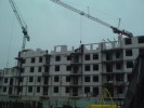
We perform quality surveys of surfaces and volumes of premises and buildings of various purposes: residential, commercial, office, retail, warehouse, industrial etc. We have got modern equipment which ensures reliable, fast and precise measurement with automatic recording of measurement results. The applied software enables to quickly calculate the required quantities and preparation of drawings in their digital format. We provide our clients with the documentation on the performed works both in the traditional format as well as digitally in the form of CAD-typed files and pdf files.
 ARCHITECTURAL - CONSTRUCTIONAL INVENTORIES
We perform architectural - constructional inventories of interiors and façades of buildings (also historic sites) for the purposes of reconstruction, repairs and arrangements etc. We make inventories of both structural elements, such as historic roof truss systems as well as interior details or architectural components. We prepare and develop drawings of façades, roofs, cross-sections, plans etc. We provide our clients with the documentation both in the traditional form as well as the digital format. We specialise in making the inventories by photogrammetric methods as well as with the aid of 3D laser scanning. >>>
 INVENTORIES OF ARCHAEOLOGICAL WORKS
We conduct inventory works at archaeological sites. We apply various measuring techniques depending on the type of position, its availability, dimensions and expected documentation. We specialise in inventories by means of photogrammetric methods by which we make inventories of these archaeological sites as well as all excavated exhibits. We provide our clients with the documentation, including the models of excavated exhibits, both in the traditional format as well as digitally in the form of CAD-typed files and pdf files. We provide the accomplished photograms digitally in the form of bitmap files.
 UPDATING THE LAND AND PROPERTY REGISTER
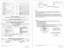
We make updates of information being the components of the land and property register. The requirement to keep the information updated results from legal regulations. Keeping the land and property register as a task commissioned by mayors of districts is made by district centres for geodetic and cartographic documentation as well as municipal centres in towns and cities with district rights. The most common causes of any such changes refer to starting or termination of the investment process within property caused by changes of the manner of its use.
 EXAMINATION OF THE LEGAL STATUS OF REAL PROPERTIES
We conduct examinations of the legal status of real properties. The determination of the state is one of the most important stages proceeding the purchase of real property being within the investor's interest. The legal status of property stands for all the rights of both tangible as well as obligatory nature which are granted in relation to the real property. Its proper disclosure is not only of importance from the standpoint of economic activities, but it is primarily in the interest of the property owner. A lack of its settled legal status is also treated as a major legal defect.
 PREPARATION OF DOCUMENTATION FOR LEGAL PURPOSES
As a result of executed geodetic and legal works such as divisions, mergers, property delimitations of real properties we prepare geodetic documentation for legal purposes. Such documentation reflects the field situation of particular real property, that is its factual land and legal state derived from, among others: a real property mortgage book and an accompanying set of documents, land and property registers, local land management plans, administrative decisions, etc. It serves as the starting material for activities performed in administrative, judicial or notary proceedings.
 STRENGTHENING BOUNDARY SIGNS
In spite of the fact that boundary signs are legally protected and their owners or land administers are obliged to maintain them in their proper conditions, it happens that they get moved, removed, damaged or destroyed. In such a situation, on behalf of our clients we restore their original conditions / location. These activities are performed on the grounds of documents allowing the determination of their original location held by the District Centre for Geodetic and Cartographic Documentation. In case of lack of such documents it is necessary to conduct delimitation proceedings.
 DIVISIONS OF REAL PROPERTIES
On behalf of our clients, we make divisions of real properties. In administrative and legal terms, a division of real property consists in determining another geodetic configuration of component land plots within the existing boundaries and without changing its current owner. Proceedings in the scope of geodetic divisions of real property involve administrative proceedings conducted by a mayor of village, town or city, respectively. Initiation of the proceedings on division of real property follows at the request of a person having a legal interest (such as an entity authorised to initiate expropriation proceedings) or on a routine basis (ex officio).
 DELIMITATION OF REAL PROPERTIES
We make delimitations consisting in establishing disputed property boundaries. In the course of these proceedings a surveyor restores the course of these boundaries in the ground on the basis of boundary traces, signs as well as documents from the land register. In case there is no such data, the surveyor accepts statements of the parties involved on the route of the boundaries. If there is no dispute on the route of the boundaries, the proceedings end with an administrative decision on determination of the course of the boundaries. The Parties may also conclude a reconciliatory agreement settling the course of the boundaries with the surveyor. Any Party satisfied with the decision may require moving the case to the court.
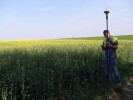
 SATELLITE MEASUREMENTS
We conduct measurements with the use of satellite navigation systems. The equipment used by us works well with the American GPS and the Russian GLONASS, and the European GALILEO system being under development. We perform measurements and calculations with all the applicable methods: from the static method up to real-time kinematic methods. Along the specialised software applied by us it provides us with an opportunity to accomplish tasks requiring precision of metres, through decimetres and centimetres up to millimetres. >>>
 PHOTOGRAMMETRIC PROJECTS
We specialise in short-range, both ground as well as aerial, photogrammetry. The short-range photogrammetry primarily stands for the accuracy of setting the ordinates at the level of individual decimetres, centimetres or even millimetres. Thanks to that, by means of photogrammetric methods, we perform projects in the scope of both land survey and height measurements and mining surveying, but also in the range of architecture, archaeology, conservation of monuments and even engineering measurements, such as inventories of objects at confined places, monitoring of deformations, determination of volumes etc. >>>
 3D LASER SCANNING
We make inventories using 3D laser scanning. We scan historic and industrial buildings, interiors, façades, natural monuments, steel constructions, operational walls of quarries, requiring detailed and prompt inventories of objects to be covered up etc. The range of applications is virtually unlimited. The technology is irreplaceable at all the places where time, precision, objectivity, completeness count. A colourful "cloud of points" being the base for implementation of derivative projects ranging from cross-sections, projections, views up to realistic 3D models comes out as the primary product. >>>
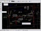
 DIGITAL PROJECTS
To our clients we offer implementation of projects which are digitally formatted both in vector-based graphics as well as bitmaps. We have got a variety of software which ensure saving end-effects in most available formats. These ones range from CAD-based files, typical bitmap files as well as file formats related to publication (including electronic publication) and printing. We scan, calibrate, vectorise archival cartographic and project documentation. We make print-outs and plotted drawings at the highest quality equipment of both minor and major format.
 TERRAIN INFORMATION SYSTEMS, GEO-INFORMATICS
We assume, implement, make updates and maintain terrain information systems. Our systems support the process of decision making and management of information relating to the geographic space in numerous business fields and industries. We make use a variety of system platforms aimed to adjust our offer to the requirements and capabilities of our clients. We are not limited by decent standalone systems. We also make network systems as well as increasingly popular geo-portals, thereby allowing access to geo-information by a large number of users. >>>
 MINING SURVEYING
We provide services in the scope of mining surveying at opencast mining plants. We set and update all the types of mining maps, including geological maps. We make inventories of resources and raw materials accumulated at dumps. We conduct legally-required supervisions of mining plants and works. We make use of various measuring techniques: ranging from traditional, using electronic tachymeters, through real time satellite measurements up to the application of photogrammetric techniques. We prepare maps using digital technologies. >>>
 AERIAL PHOTOGRAPHY
As the company specialising in photogrammetry services we have got the experience and equipment, so that to our clients we offer imaging "from bird's eye view". For this purpose we most often use our photogrammetric balloon constructed on the basis of our design, which lifts a high-class reflex camera up to the level of 200 metres. Whatever is photographed at the moment is available at the screen at the ground. Remote control of camera rotation is also done from the ground. We use a leased plane to take imaging from higher levels. As far as possible - we invite you to joint the flight!